Access to information about cartographic materials in the National Library of Poland has been improved by new functionalities intended to keep up with users’ new needs and technological trends. From mid-January 2010 on readers of maps and atlases kept in the library can find catalogue descriptions of these materials through the special website. Three different forms of access to descriptions of cartographic materials are available on the website: (1) Catalogues/Catalogues online — database search in the central computer catalogue of the National Library of Poland (NLP); (2) Bibliographies online. Cartographic documents [download .pdf files — in Polish]; (3) Bibliographies online. Cartographic documents [search database] — access to the database in the MAK system containing items from the published bibliography of cartographic materials.
The main purpose of the catalogue and bibliography of maps, atlases and globes published in Poland is to serve vast circles of users: library employees, researchers, students and other readers interested in finding a certain map, e.g. travelers and hobbyists. The selection of search tools available to the reader is just as important here as the choice of description standards which are used by a librarian who wants to cater to present needs and be comprehensible to all potential users.
In order for a catalogue and a bibliography (offline or online) to be able to serve its purpose, the descriptions must fulfil two functions: explicit identification of the described document and conveying information about the document as well as its content. The first function is fulfilled by determining the description entity and the selection of its elements, such as the title, the author, the edition, mathematical data, the publisher’s address, remarks, and their scrupulous interpretation. This is a fundamental objective of every bibliographer. The second function — conveying information about the factual value of a document — is fulfilled mainly by adding remarks which should not only be supplementary and explanatory to the elements of the bibliographic description identified earlier, but also should describe the content of the graphic part of the document and possibilities for its usage, for instance in research and education.
Since the beginning of the 21st century, our catalogue and bibliography have been under revision. First, we revised the rules of cartographic cataloguing in order to adapt them to the NLP library catalogue system and format for books and periodicals which had been introduced earlier. A provisional instruction by Aniela Drozdowska[1] was replaced by the Polish norm, and later — step by step — we created methodological principles for cataloguing maps and atlases.
Since 2001 all the bibliographical descriptions of maps and atlases in the National Library of Poland have been made according to Polish Standard PN-N-01152-5 Bibliographic Description. Cartographic Materials,[2] whose concept has been elaborated by the staff of the NLP: Maria Janowska from the Centre of Standardisation of the Bibliographic Institute and Lucyna Szaniawska from the Map Department. Our starting point was the norm prepared under the auspices of the International Federation of Library Associations and Institutions ISBD (CM): International Standard Bibliographic Description for Cartographic Materials published in 1987 and its next edition (Revised Version 1999).[3] The most important recent instructions for describing cartographic materials in Poland include:
-
Format MARC 21 rekordu bibliograficznego wraz z zasobem: adaptacja dla systemu MAK: wersja 2008 [= MARC 21 Format for Bibliographic and Holdings Data: Adaptation for the MAK system] / Edited and elaborated by Agnieszka Brachfogel, Zofia Żurawińska; in collaboration with Bożena Bartoszewicz-Fabiańska, Paulina Czyżewicz. Warszawa: Biblioteka Narodowa, 2008;
-
Opis książki w formacie MARC 21: zasady tworzenia rekordu bibliograficznego i rekordu egzemplarza w systemie INNOPAC w Bibliotece Narodowej [= Book Description in MARC 21 Format: Rules to create bibliographic and item record in the INNOPAC System in the National Library] / Elaborated by Zofia Byczkowska. Warszawa: Biblioteka Narodowa, 2002;
-
Format MARC 21 rekordu bibliograficznego dla dokumentu kartograficznego [online] [= MARC 21 Format for bibliographic record for Cartographic Materials — online] / Elaborated by Grażyna Dudzicka, Dorota Gazicka, Irena Grzybowska. [Warszawa]: Centrum NUKAT, July 2007 (available on the Internet);
-
Format MARC 21 rekordu bibliograficznego. Dokumenty ikonograficzne. Wersja 2008 [= MARC 21 Format for bibliographic record for Visual Materials. Version 2008] / Elaborated by Agata Pietrzak. Warszawa: Biblioteka Narodowa, 2008.
In preparing some of the description formats, a number of other publications proved to be very helpful, such as the rules and applications contained in the Anglo-American Cataloguing Rules (Second Edition, 1988, chapter 3, Cartographic Materials) and explanations and examples included in the Handbook for AACR 2 Explaining and Illustrating Anglo-American Cataloguing Rules (Second Edition; American Library Association, 1988). In certain cases, international rules compiled by and published on the IFLA web site since 2004 as the ISBD(CM) International Standard Bibliographic Description for Cartographic Materials (200x Revision), were also taken into consideration. Furthermore, bibliographic descriptions of atlases may be based on another standard: PN-91-N-01152-8 Opis bibliograficzny. Stare druki [= Bibliographic Description. Early Printed Books], published 1994 and Format MARC 21 rekordu bibliograficznego dla starych druków [online] [= MARC 21 Format for Bibliographic Description. Early Printed Books] Elaborated by Halina Mieczkowska. [Warszawa]: Centrum NUKAT, December 2007 (available on the Internet).
Figure 1 shows how the rules were applied to the standard description scheme. It shows that the third level of detail is used, which includes all the elements allowed for in the Polish Standard. Every description is preceded by a password created from a geographic name which most closely denotes the map’s range, plus the scale of the dominating part of object. When recording map data the abbreviations used are in accordance with Polska NormaPN-85/N-01158Skróty wyrazów i wyrażeń w opisie bibliograficznym [= Polish Standard PN-85/N-01158 Abbreviations of words and phrases in bibliographic description], which has been in force since 1987. The standard does not cover descriptive phrases used quite often by Polish authors of maps and atlases and words generally connected with their content. Therefore, correct bibliographic description of cartographic materials required the introduction of the following abbreviations: aktual. [update], dł. geogr. [longitude], dystr. [distribution], geogr. [geographic], hydrogr. [hydrographic], kartogr. [cartographic], krajozn. [heritage tourism], płd. [southern], szer. geogr. [latitude], tech. [technical], topogr. [topographic], turyst. [tourist], kolor. [colour], zdj. terenowe [field survey]. Also Latin abbreviations, for example ‘ca’ or ‘et al.’, were standardized. In the mathematical data field international abbreviations for geographic directions (N, S, W, E) are used, which are functional in the MARC 21 format.
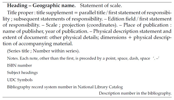
Figure 1: Standard description scheme of a cartographic object in the ‘Bibliography of Cartographic Materials’.
In order to ensure uniformity of the descriptions, many practical problems had to be solved. Because of the fact that in the INNOPAC database of the NLP abbreviations taken from Latin are applied, such as ca, s.l., s.n., et al., Latin words such as verso and recto were also introduced. At present an entry may read, for example, ‘Verso: tekst turyst.-krajozn.’ [Verso: tourist. text].
(1) Since 2002 all bibliographic descriptions of maps and atlases were entered in MARC 21 format and added to a computer catalogue database installed on the NLP server, which operates on INNOPAC belongs to the Map Department. In the OPAC (open public access catalogue) a special user version of the record is shown under ‘catalogues’ in the NLP online catalogue, which facilitates quick access.
The less accessible MARC 21 version is also available for use by those librarians who are familiar with the format. The entity of a bibliographic record is an independently published cartographic material, which is most often identified by the publisher by assigning the ISBN number. The materials are registered on the so-called first level of description and for that reason the series of maps and multi-sheet maps as a whole are not described in the bibliography but their sheets which appear under their own title.[4] Their records are connected with an additional password of a uniform title put under a label ‘Seria’ [Series] (in OPAC) or in the data field 830 (in MARC 21), e.g. ‘Mapa topograficzna Polski 1:50 000. Ukł. 1992 ; M-43-6-B’ [Topographical Map of Poland 1:50 000. System 1992; M-43-6-B].
Figure 2 shows an example of a map description of the Grójec environs published in 2004. In this manner, almost 12,000 maps and atlases from the collection of the Map Department were described in the database.
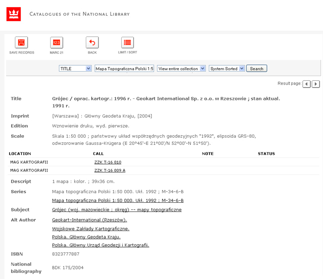
Figure 2: A screenshot of an exemplary tourist map from the “CATALOGUES” screen.
In addition to the version of the descriptions available online under ‘catalogues’, the ‘Bibliography of Cartographic Materials’ = ‘Bibliografia Dokumentów Kartograficznych’ (Polish abbreviation: BDK) was prepared by the NLP Map Department and published in the years 2005–2008 biannually as part of the current Polish national bibliography. Seven volumes were published: 2002 No. 1, 2002 No. 2, 2003 No. 1, 2003 No. 2, 2004 No. 1–2, 2005 No. 1–2, 2006 No. 1–2. The next issue, 2007 No. 1–2, was not published in print, but was converted to a .pdf file and put on the NLP website under the heading ‘special bibliographies’. The BDK registers all types of cartographic materials (maps, atlases, globes)[5] on the basis of copies which are sent as a legal deposit to the NLP by publishers.
The printed version descriptions were alphabetically organised by geographical entries and then by map scales in descending order. Each issue of the BDK was accompanied by seven indexes: map titles, atlas titles, corporate names, personal names, series of sheets, subjective entries, ISBN number.
Index sheets constituted an additional multi-sheet maps search tool.[6] Considering the fact that vast areas of the country have not yet been sheeted, displaying the availability or lack of maps is very important information for a reader. Index maps used to be prepared (and they still are for the .pdf file version) in cooperation with the Head Office of Geodesy and Cartography and the Hydrographic Office of the Polish Navy, which supervise topographic, hydrographic, environmental and sea navigation maps production.
(2) In 2009, the printed version was superseded by an electronic .pdf file, which is commonly used for displaying texts on the Internet. Up to now, the following new ‘BDK’ issues have been created: 2007 No. 1–2 and 2009 (January–December, containing mainly descriptions from the years 2008–2009). Maps and atlases which were not registered in the previous issues but were sent to the NLP until the end of 2009, were also added.
Besides the medium of publication, quite a few other changes have been introduced, including a new configuration of the main part of the bibliography number. For the first time a bibliographic descriptions arrangement has been introduced which is compatible with the UDC standard subdivisions order. Symbols to be used in the bibliography were derived from UDC tables published in Uniwersalna Klasyfikacja Dziesiętna: publikacja nr UDC-PO58 autoryzowana przez Konsorcjum UKD nr licencji UDC-2005/06. Wydanie skrócone dla bieżącej bibliografii narodowej i bibliotek publicznych [= Universal Decimal Clasification: Edition No. UDC-PO58 authorised by UDC Consortium License No. UDC-2005/06. Short edition for national bibliography and public libraries]. The simplified list of UDC symbols is presented near the introduction. Only within divisions and subdivisions are the descriptions sorted in alphabetical order according to the names of geographical entries (Figure 3).

Figure 3:An outline of UDC divisions and subdivisions applied to the BDK.
An additional change is the possibility to retrieve a data field 653 Index Term — Uncontrolled entry from the INNOPAC database, by means of which it is possible to determine more efficiently than previously (by the field 651 Subject Added Entry — Geographic Name subfield ‘a’ ‘Geographic name’) the range of the entire object described. In this way supplementary information could be added to names, e.g. Bytnica (okolice [= environs]) — which means that the map represents the town with its unspecified surroundings. Illustration of another written form are elements of sheets description of multi-sheet maps — e.g. ‘Brzeźnica (gmina [= commune])’ means that the map represents the area of the commune together with the seat of its authorities, and ‘Zamość’ indicates a general plan of the town. Other elements of the map and atlas description have been left unchanged (Figure 4).
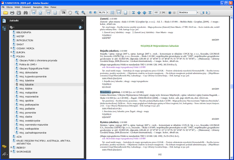
Figure 4: A screenshot of a description of exemplary maps from the BDK screen in a pdf file.
Together with the introduction of the .pdf format, the BDK introduced new presentation and navigation tools connected with this format. One of them is the possibility to use bookmarks during the search of the BDK number. The .pdf file functions in a similar way as the tables of contents in books do and after clicking on them they refer the reader straight to particular parts of the bibliography: divisions and subdivisions of UDC and particular indexes.
The electronic form of the bibliography contains all indexes previously included in the printed version, i.e. map titles index, atlas titles index, causative institutions index, personal name index, ISBN numbers index, series sheets index and subject headings index. To the indexes themselves some new search tools have been added, namely links between each description number given in an index entry and the description to which the entry pertains. For example, in the map title index, right after the title ‘Białystok : plan miasta 1:17 000’ the description number has been marked with purple, and by clicking on it the user goes directly to the full description of the map.
As stated before, the characteristic feature of the Polish ‘Bibliography of Cartographic Materials’ was the fact that it included printed index maps. Moreover, in 2009 sheet tablets for land maps of the following series were included: Mapa hydrograficzna Polski 1:50 000, Mapa sozologiczna Polski 1:50 000, Mapa topograficzna Polski 1:10 000 as well the series of many scales charts: International Charts Series and Morskie Mapy Nawigacyjne. The images of indexes were put in jpeg format (Figure 5). After each display of a series title in a full bibliographic description, links to a proper sheet tablet series were added.[7] In the near future we plan to add links to each cell symbolising a map sheet in the index to its bibliographic description.
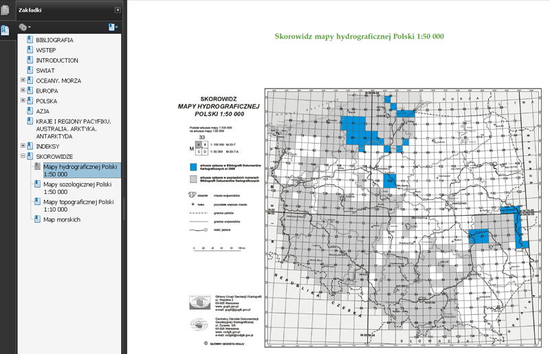
Figure 5: A screenshot from an index of Mapa hydrograficzna Polski 1:50 000.
A file in .pdf is maybe not the most modern search tool, but it has two very important advantages: it is relatively cheap in production, it does not require any special tools for text searching within a bibliographic number and it provides the reader with an opportunity to print out some material derived from the published editions up to 2007, for his own needs.
(3) The third way of accessing the ‘Bibliografia Dokumentów Kartograficznych = Bibliography of Cartographic Materials’ is the database of the National Library of Poland in the MAK system, which was installed on NLP staff’s computers in the end of the 1980s. Since 1991 ‘Przewodnik Bibliograficzny’ [= Bibliographic Guide] has been working with this system, cataloguing all the books published in Poland, among which there were also maps and atlases. Cartographic materials were, in fact, described just like books; it was their first current registration. Since 1998 the MAKWWW system has been in operation. It has been reprogrammed to be used on the http://mak.bn.org.pl web page. Since 2002, it has been used provide access to many different library databases, e.g. the national bibliography and special bibliographies. Among others there is a database: cartographic materials. It was installed on 20 October 2008 and it contains 5,630 bibliographic records. Untill May 2010 it was visited by 9,820 readers from outside the NLP building. Naturally, there are typical choice options which serve as search tools and which are used in other library collections as well, such as books, periodicals, journal articles, electronic and audio documents.
Basic searches can be made by selecting the author’s name, the title, the keyword, the subject access entry, the publisher’s name, international number (ISBN or ISSN), the number of the bibliography item, the year of publication and the series title. Another method, which is actually a form of advanced search, makes it possible to narrow down a search area with the help of several (up to five) criteria, joined by the conjunction ‘or’ and ‘and’ (Figure 6). Another way of advanced search consists of choosing an entry in the index combined with the possibility of replacing the ending of a word with an asterisk.
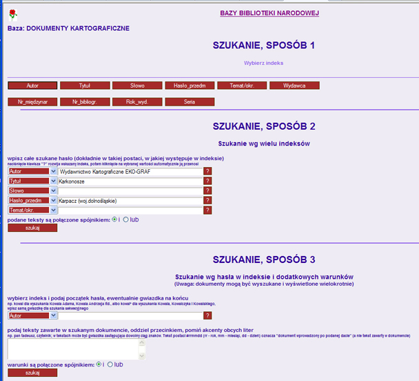
Figure 6: Various methods of advanced search in the cartographic materials database in the MAK system.
The interface for bibliographic descriptions in the MAKWWW database for cartographic materials has a very clear typeface when compared to other similar databases in the leading European libraries (Figure 7). Because the only documents described are maps and atlases, the search for maps on a certain subject or maps of a certain area is very fast and precise. A similar search in the central database, to which over one million four hundred thousand descriptions of library entities have been added without the use of an advanced search query, renders too many results. For example, when one enters ‘Warszawa’ into the central database as the beginning of the title, the catalogue returns 1,733 hits, among which only a few concern maps — most of the hits concern books, guides, albums, prints, etc. If one enters ‘Warszawa’ as a subject in a subject entry, the result is even more useless — over 10,000 hits.[8] However, a similar search query by means of an advanced search, with the delimiter ‘DOK.KART.’ [= MAP in an English catalogue interface] returns 290 to 608 hits. In the MAKWWW database 48 titles (tytuł in Polish) starting with the phrase ‘Warszawa’ and 203 subject entries (hasło_przedm in Polish) with the subject ‘Warszawa’ will be found.
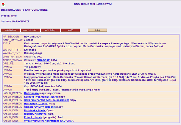
Figure 7: Screenshot with a bibliographic description of a tourist map of the Karkonosze Mountains.
Unfortunately, the inconvenience of this database is that only maps and atlases produced since 2000 have been included at present; however, a retrospective inclusion of cartographic materials published after World War II is being planned together with cartographic materials published since 1928, which is the date when ‘Przewodnik Bibliograficzny’ first started.
A marginal remark: the criteria of advanced search are far more challenging for a reader than the previous tools. For example, if one searches something by means of the keyword ‘Warszawa’ and limits the search to the type of document ‘DOK.KART.’ [MAP in the English Catalogue interface] by means of the delimiter ‘and’, one will get 7,870 hits. In the MAKWWW database the corresponding outcome is 301 hits. This shows that the search types have been incorrectly used. Using the name ‘Warsaw’ as a keyword, one must be aware of the fact that the hits will include not only appearances in the title (and not only at the first position) but also in the place of publication, the place of printing, in the corporate name and, in the notes, cartographic material which does not represents Warsaw at all (Figure 8).

Figure 8: Advanced search results by means of the keyword ‘Warszawa’.
The work on providing access to online descriptions of cartographic materials in the databases of the NLP catalogue and bibliography has greatly accelerated this year. However, there are still many years to come before the library staff will be able to say: ‘it is done’ and the entire, still growing collection will be catalogued. It is also necessary to add some modern navigators presenting images of high resolution maps. Still, by providing online access to data, the NLP has joined the ranks of other leading European libraries. It is only fairly recently that many European libraries began discussing the option of moving from analogue to online bibliographies of cartographic materials.
Some countries, such as France in 2000 and Denmark in 2004, ceased printed publication altogether, but there are still some countries, like Germany, which print map and atlas bibliographies.[9] As a matter of fact, however, almost every library has a collection of catalogues available online or they burn them on CD’s in order to be able to sell them. In Poland, it appears, returning to the printed form is neither possible nor justified, because every reader can download the file and print it.
|
Aniela Drozdowska, Przepisy tymczasowe katalogowania i inwentaryzowania zbiorów kartograficznych. [= Project of instruction for cataloguing and holding cartographic collections]. ‘Biuletyn Geograficzny’. Instytut Geografii PAN, z. 11, 1954. |
|
|
Polska Norma PN-N-01152-5 Opis bibliograficzny. Dokumenty kartograficzne. Warszawa: Polski Komitet Normalizacyjny, 2001. |
|
|
New version of this norm: IFLA International Federation of Library Associations and Institutions ISBD(CM):International Standard Bibliographic Description for Cartographic Materials. 200x Revision. Prepared by the ISBD(CM) Working Group for approval by the Standing Committees of the IFLA Cataloging Section. http://www.ifla.org/VII/s13/pubs/ISBD(CM)_21Dec04.pdf |
|
|
Basic information on the manner of map and atlas registration in ‘Bibliography of Cartographic Materials’ is to be found in each issue of the bibliography. It is the subject of Jerzy Ostrowski’s review ‘Bibliography of Cartographic Materials’ in Polish Cartographical Review, Vol. 39, 2007, No. 3, p. 271–273. |
|
|
The Bibliography does not contain a description of the cartographic materials in electronic form, because they are registered together with other electronic documents in addition to ‘Bibliographic Guide’ entitled ‘Bibliografia Dokumentow Elektronicznych’ [= Bibliography of Electronic Resources]. However, the electronic materials accompanying the printed cartographic materials are taken into consideration. |
|
|
Lucyna Szaniawska: Project to include Index Sheets in the Polish National Bibliography of Cartographic Materials’, LIBER Quarterly, Vol. 15 (2005), no 1–4, p. 65–74; http://liber-maps.kb.nl/articles/14szaniawska.html. |
|
|
A similar method, although realised by means of other technical solutions, was used by Pan´stwowy Instytut Geologiczny [= Polish Geological Institute]. Textual bibliographical descriptions have been connected with the indexes available on the institute webpage with links, which enabled accessing information about map sheets. |
|
|
Since the beginning of 2001, research on improving the utility of a subjective entry has been conducted; among others Field 655 Index Term — Genre/Form has been used. A considerable improvement may only prove possible after the database itself is updated. To be fairt, the geographical names ‘Warszawa’ and ‘Polska’ are, for obvious reasons, extreme examples in the Polish library database. |
|
|
The presentation of bibliographies in chosen countries was a subject of a note by Lucyna Szaniawska entitled Polska ‘Bibliografia Dokumentów Kartograficznych’ na tle wybranych bibliografii w innych krajach europejskich [= Bibliography of Cartographic Materials in comparison with the chosen bibliographies in the European countries], in: ‘Polish Cartographical Review’, Vol. 38, 2006, No. 38, No. 4, p. 326–329. |