National Library of Norway's new database of 22 manuscript maps concerning the Swedish King Charles XII's campaign in Norway
in 1716 and 1718
INTRODUCTION
The National Library of Norway is planning to digitise approximately 1,500 manuscript maps. Two years ago we started working on a pilot project, and for this purpose we chose 22 maps small enough to be photographed in one piece. We made slides 6 x 7 cm in size, converted the slides into PhotoCDs and used four different resolutions on JPEG-files. To avoid large file sizes, we had to divide the version with the biggest resolution into four pieces. The preliminary work was done in Photoshop, the database on the web is made in Oracle. You can click on the map to zoom. Norwegians and probably Swedes during the Great Northern War drew the 22 maps when the Swedish King Charles XII in 1716 and 1718 unsuccessfully attempted to conquer Norway.
The database is now accessible on the National Library of Norway's web site. The database is in Norwegian, but we are working on an English version as well.
The maps are searchable on different topics, countries, counties, geographical names, shelfmarks or a combination of these. We are planning to expand the database to other manuscript maps later. This is the reason why it is possible to search for obvious subjects as Charles XII and the Great Northern War.
FIRST CAMPAIGN 1716
King Charles' first campaign to conquer Oslo in 1716 was not a success. Charles failed, retreated and tried instead to conquer the fortress Fredriksten in the town Halden. The citizens managed to get rid of Charles by putting their own city on fire. This is mentioned in the National Anthem of Norway.
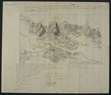
Fig. 1
SECOND CAMPAIGN 1718
The second campaign was actually two campaigns, one in the county of Østfold, in the Southeast of Norway, and one in the county of Trøndelag near the city Trondheim in the middle of Norway. Charles himself headed for the Fredriksten fortress again, and this time he came with an army numbering 40,000 men.
At the same time General Armfeldt, led 10,000 men aiming for Trondheim. Sweden had been at war for so long that the quality of Armfeldt's soldiers was quite low. Many of them were Swedish rural boys from the counties of Jemtland and Herjedalen. This is the area just across the border from Trondheim. Jemtland and Herjedalen were lost to Sweden at the peace of Brømsebro in 1645, so motivating the soldiers to fight against their own relatives was quite difficult. For this, Armfeldt brought Finnish mercenaries with him.
Armfeldt crossed the Norwegian border Northeast of Trondheim, behaving like armies usually do, plundering and burning. Armfeldt came to Stene entrenchment and beat the Norwegians in September 1718. The victory at Stene allowed a gateway through to Trondheim, but because of a combination of epidemic diseases and lack of heavy artillery, Armfeldt failed to take Trondheim.
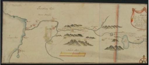
Fig. 2
THE RETREAT
The retreat from Østfold did not cause any losses. But in the north, in Trøndelag, General Armfeldt got the message three weeks later. On 12 January 1719 he started the retreat. The army split,
but the main part went south and tried to cross the Swedish border through an area called the Tydal Mountains. This is an
alpine landscape; the mountains are from 1000-1700 metres high, with a cold climate in the wintertime, which makes it quite
a rough area if you are not properly dressed. The database contains maps showing different routes.A cartographer called Klüwer probably makes this map. It is not signed, but it is possible to recognise his handwriting. Klüwer was a family of officers from the area around Trondheim, with at least two cartographers. The map is probably made in the 1750-60s.
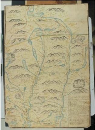
Fig. 3
WEB SITES REFERRED TO IN THE TEXT
Database of 22 manuscript maps concerning the Swedish King Charles XII's campaign in Norway in 1716 and 1718: http://www.nb.no/karl-xii-kart/index.html
LIBER Quarterly, Volume 13 (2003), No. 1