(On the Example of the Kraków Voivodeship Computer Atlas)
When new technologies were introduced in cartography, and especially computer technologies and Geographic Information Systems (GIS), maps and atlases began to be used in a different way. Passive forms (reviewing, overlap drawing) have been replaced by more active forms (generating new information, visualisation and animation of the spatial data). Thus cartographic collections in libraries are to play a different role. It is necessary to adjust them to the use of maps existing on electronic media, recorded on disks or CD-ROMs, offering a possibility to scan and print the data. Simple programmes which visualise spatial data should also be available in libraries. In the near future the major role in cartographic collections will be probably played by electronic atlases consisting of aggregated data bases (geographic, statistic and others) composed of many layers and attributes which will be combined according to the user’s needs and thus new maps will be created. The Kraków Voivodeship Computer Atlas (KVCA) which is now being prepared in Kraków is such an electronic atlas. In this paper, the author presents some remarks about this new type of the regional atlas on the basis of experience acquired in preparing of this atlas.
The main information base were regional atlases prepared in the traditional form during the 1980s (and before) and the development of methodology solutions for thematic cartography (for example, twenty years ago the author developed and edited the Atlas of the Kraków City Voivodeship (Atlas Miejskiego Województwa Krakowskiego) in traditional paper form). Currently, due to the widespread introduction of computer systems their form must undergo a change. Primarily, this is the result of practical management needs which requires immediate and upgraded information, including the possibility of their correlation. Therefore, should this new form of atlas be a computerised version of the traditional maps, or should it, through an integrated base of various types of data (spatial, statistic, descriptive) be the background for creating a system which can be queried? This latter form would need to create a cartographic output, and, therefore, will possess geographic location, (scale), sign code, and characteristics expressing quality and quantity.
The computer atlas complies with the conditions of cartographic presentation for various types of contents, including simple and easy upgrading and creating certain advanced procedures (e.g. in the scope of generalisation, framing, change of scale, graphic variants, etc.) The atlas will continue to be only a ‚set of maps’ defined by the author of the atlas. However, it is impossible to foresee all the needs of its end-users and utilise all the possibilities for generating further information set in the contents of each map and not indicated in a simple manner, such as deriving from map legend. Their ‚presentation’ is only possible via GIS procedures permitting, in essence, arbitrary associations of various pieces of information to obtain and create new and different maps. The result, the so-called ‚GIS Atlas’ would not become a closed set of concrete maps but rather a set of problematic questions and procedures which when applied would generate the answers. Of course, in both cases, the database is within the computer memory, however, in the case of the ‚computer atlas’ the selection of information is adapted to a concrete thematic map, and for the GIS Atlas, to a concrete problem or question which often requires associating information (data) deriving from several different maps. Naturally, each ‚question‘ may be associated with a certain thematic map but not necessarily an atlas map. The atlas is always a certain ordered sequence and must fulfil the conditions of unity which are not necessary for an ad hoc analysis in response to specific needs.
The philosophy of the ‚GIS Atlas’ exceeds the traditional understanding of cartography and the atlas as a cartographic achievement. However, it continues to exist as a cartographic work primarily because it maintains cartographic standards such as scale, representation, basic (topographic) elements, and cartographic means of expression. Developing the computer atlas of the Kraków Voivodeship, we intend to secure both the computer atlas form as well as GIS Atlas. The information obtained from a survey indicates that the potential users consider both as useful and even complementary.
OBJECTIVE AND PURPOSE OF THE KVCA
The objective and purpose for developing the computer atlas of the Kraków Voivodeship is to make it available to authorities and public institutions, including government administration in an integrated and spatial data base form. This database will include the basic elements of the natural environment as well as aspects of the social and economic life in the Kraków Voivodeship, enabling both to be analysed as visual concrete phenomena. Traditional cartographic development allowed the achievement of this possibility in a limited scope, requiring comparative studies, sketches, etc. to obtain results that could demonstrate quite different patterns with the same data. The cartographic image appearing on the screen is currently the main working tool for using spatial information systems. This does not exclude the possibility of preparing a paper copy of the map using a printer, plotter or any other advanced reproduction technology.
The users of the KVCA are also institutions for which current information concerning the region is the basis for further scientific, and/or educational research. Development of selected thematic map sets on diskettes or other computer software is seen to serve as a generally accessible and popular form of information about the Voivodeship.
GENERAL DEVELOPMENT PRINCIPLES
The regional computer atlas clearly requires a different approach regarding the concept of its construction than in the case of a traditional atlas. It is obvious that the construction of the atlas in a virtual computer dimension allows for different circumstances for creating maps. However, these continue to be graphically expressed ‚models of reality’. Approaching maps as GIS managed ‚information layers’ does not necessarily mean disregarding the basic atlas attributes as a cartographic work, both from an official view point (representation, scale, format) as well as the contents (completeness, comparability, sequence, complexity, uniformity of general principles and methods of graphic presentation). An individual set of characteristics of each thematic map will be maintained. Agreeing and minimising considerable discrepancies will be conducted between individual thematic layers, especially regarding the basic map. Although there are many possibilities of connecting various information layers or attributes for achieving concrete practical objectives, the KVCA will maintain recognised standards appropriate for respective fields. It is necessary to state that each thematic map, especially concerning geographic environment elements, has evolved, and a certain standard has been developed. These maps are already in circulation and of practical use. This does not mean that individual elements (layers) of these standard sets cannot be applied in completely specific combinations, creating new information quality.
ATLAS CONCEPT ASSUMPTIONS
- The atlas will contain two main groups of maps: physical and socioeconomic. The physical maps will be developed in detail and with precision appropriate to standards recognised for conventional maps in a scale of 1:100,000. Such a scale is acknowledged as basic (initial) for environmental content. On the other hand, the socio-economic maps based upon statistical data are prepared in a scale of 1:300,000.
- Support materials for constructing each of the KVCA information layers are existing cartographic developments in the form of printed maps, editorial copies, or manuscript maps and data base (statistic and monitoring), as well as aerial photographs and satellite images. It will be necessary to use ready made graphic and tabular developments in the form of computer files (or their supplements) owned by certain institutions such as the Institute of Meteorology and Water Economy, National Institute of Geology, Voivode Statistic Office and others.
- The base map shall play a major role. This map is a set of information layers: hydrographic, road network, developed areas, administrative limits. The working scale is 1:50,000. The base map will be developed via updating topographic maps in a scale of 1:50,000 or 1:100,000. Updating topographic information layers and land use maps will be developed using as a base, computer analysis of satellite images LANDSAT TM, dated August 1992 (resolution 30 m.), and SPOT, dated November 1994 (resolution 10 m.).
- An important element of KVCA is the digital terrain model (DTM) which for many thematic maps will serve as a basic layer. The DTM is necessary for modelling phenomena functioning as terrain relief, and permits three-dimensional presentation.
- It is assumed that the graphic part of the KVCA will be represented in two forms: vector and raster. The vector register is recognised as primary, and the raster as secondary. The basic raster pixel has been assumed as equal 50x50 m (resolution). Raster representation (grid, cell) is planned for conducting spatial analysis. Only analysis based upon line items will use the vector register.
- The basic operation for transferring physical map contents into the virtual environment will be screen vectoring preceded by scanning or table digitalisation. The first method is foreseen for maps including a large number of graphic elements (e.g. topographic maps) the latter for thematic maps of a less complex drawing content.
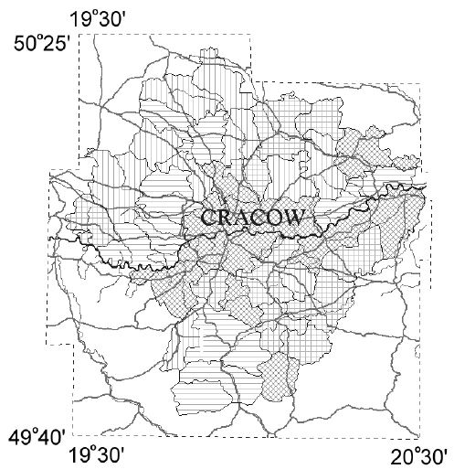
Figure 1: Kraków Voivodeship area on the KVCA - frame. - Each map designated for vectoring will first be edited to harmonise the scope (contours) correlative separations reflecting correlation actually existing in reality and present on various maps. Special attention will be made to preserve physical borders (e.g. tectonic borders, stretches of river terraces, etc.) During editing, it will be necessary to maintain complete consistency with the base map and geomorphologic elements included in the DTM.
- Thematic layers creating individual maps are, in principle, without text. Name sheets will be prepared which will be separate ‚layers’. It will always be possible to connect them with other layers and, therefore, locate the phenomena. Also, geographic names and other descriptions will be inserted in attribute tables.
- Social and economic maps will be based on statistical data covering the communes (gminy) received during the last census.
- The MGE INTERGRAPH system has been selected for the development and target use of KVCA. Collecting, completing, and constructing the data base structure of KVCA will be managed on a workstations equipped with MGE modules and SQL Microsoft base (Oracle, Informix - option) operating in the Windows NT environment. Certain elements of the development (e.g. digitisation) are planned for PCs with MGE-PC, Idrisi, or Auto-CAD software. DXF will be used as a standard for the exchange of graphic (vector) data, DBF for text and numerical data, and TIFF for raster data.
- The computer atlas may be used on a PC with MGE-PC and Vista Map for Windows. The users of other GIS tools will have to convert the KVCA database. Conversion to MapInfo is supplied. The raster registration will be paralleled in Intergraph and TIFF, permitting simple exchange of this type of information between various systems. For grid analysis it is recommended to use the module MGE Grid Analyst PC, and Idrisi. It will also be possible to use other tools accepting TIFF format and with a simple structure of an attached attribute table.
The KVCA database will contain the graphic and text portions. Amongst the two separate graphic presentations, the link with the text database will have a vector model. The following hierarchy has been accepted for the structure of graphic data (characteristic for MGE systems): map group, i.e. map index - categories - objects - maps - layers. Each map may consist of 63 layers and may additionally be associated with 256 reference maps. Each map will contain a table with descriptive data (attribute table). The display of a feature will be in accordance with the convention of cartographic separation for each thematic map. During the phase of vectoring and loading the database it will be necessary to submit only one feature per layer of the drawing in DGN format. - Each vector represented map will include comments and remarks regarding feature location (separations) in the DGN file layer and describing the possibilities of connecting these layers with the layers of other maps. It will also contain practical application guidance including development sources (institutions, publishers, authors).
- The atlas will be an ‚open system’, i.e. as new data (new maps) are developed, these will be introduced into the database. This also refers to upgrading already input data.
- It is planned that the users of the atlas will have free access to a demonstration version of the atlas via the Internet. Network access to the complete database will also be considered but only for authorised users.
METHODOLOGY FOR DEVELOPING THE KVCA
- Map scanning and not table digitalisation. All thematic maps developed earlier are scanned and then digitised on the basis of the visual raster image on the monitor screen;
- Feature character of digitisation, i.e. the necessary geometric conditions are preserved for cross point line, surface (closed envelope);
- The base map is developed with more detail than usual, based on the 1:50,000 topographic maps;
- Upgrading based upon geometric SPOT images and partially aerial photography is managed simultaneously with topographic map digitisation;
- Statistical data is input, depending on the possibilities from ready made computer files and attached as a relational table;
- Apart from the existing base map, a basic raster image is prepared taken from satellite SPOT and LANDSAT data, making it very easy to review thematic maps;
- Certain portions of the information are in both the vector and raster form allowing the user to select the method of analysis (linear or grid).
AN EXAMPLE OF USING SOME INFORMATION LAYERS (GIS DATABASE):
| Question 1: | Where are the communities with worse soils? Answer: map in fig. 2. |
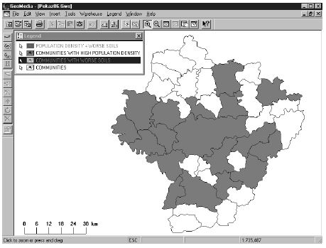
Figure 2
| Question 2: | Where are the communities with high population density? Answer: map in fig. 3. |
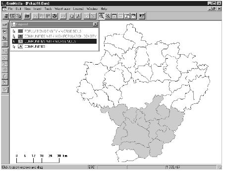
Figure 3
| Question 3: | Where are the communities with worse soils and high population density? Answer: map in fig. 4 (in black). |
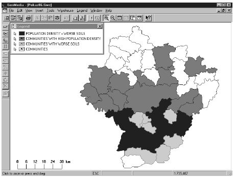
Figure 4
GLOSSARY OF ABBREVIATIONS
DBF = Data Base File
DGN = DesiGN file format
DTM = Digital Terrain Model
DXF = Digital eXchange Format
GIS = Geographic Information System
MGE = Microstation GIS Environment
TIFF = Tagged Image File Format
REFERENCES
Atlas Miejskiego Województwa Krakowskiego. Oddzia PAN w Krakowie, 1979
Trafas K., Pyka K. The future of the regional Atlas: computer or GIS Atlas?
Proceedings vol. IV 18th ICA/ACI International Cartographic Conference, Stockholm 1997.
Kazimierz Trafas
The Geographical Institute of the Jagiellonian University
Ul. Grodzka 64
31-44 Kraków, Poland